I don’t own an electric vehicle (EV), but I rented one in the summer and drove it from Vancouver to Manitoba. I learned a lot on that road trip about driving an EV, the different kinds of chargers, and range anxiety.

Fast chargers allow electric vehicles to charge up to 80% in around 30 minutes. The growing number of chargers along major highways has made road-tripping possible. When I was planning our trip, I found existing maps of the charging network. But they didn’t answer a fundamental question, “Can we get all the way from Vancouver to Manitoba?” I had to map out the drive and plot each charging stop to ensure there weren’t any segments longer than our range. There was only one – a 530 km stretch of the Yellowhead Highway through Manitoba and Saskatchewan without a single fast charger that we had to detour around it.
When I returned from that trip, I was inspired to create a better visualization of the highway system that easily showed which routes were EV accessible.
Canada’s EV Network
The theoretical range of the Hyundai Kona I drove is 415 km, but I quickly realized you can’t drive that far between charges. Air conditioning, heating, headwinds, hills, and heavy cargo conspire to reduce the theoretical range. Plus, with fast-changing, you rarely charge to 100%. The longest segment we did on that trip was 280km.
For my analysis, I labelled highways based on their distance to the nearest fast charger. Even if you can travel 300 km on a charge, you don’t want to drive a section of highway that forces you to. Ideally, you can skip a broken or busy charger and continue on to the next city without fear of running out of battery.
These are the categories I came up with. I think they apply broadly to most EVs.
- Great: < 50 km from a charger. No need to route plan; just look for the next charger when you get low.
- Good: 50-100 km. Stress-free driving.
- Doable: 100-200 km. Route planning is required, but you have backup options.
- Hard: 200-300 km. Pray that there isn’t a broken charger or a queue.
- Risky: 300-350 km. If everything goes right, you might just make it.
- Inaccessible: >350 km. Don’t bother.
With these categories, this is what Canada’s highway network looks like in terms of access to fast charging. Note: The maps below are for the popular CCS connectors. When I ran the analysis for CHAdeMO and Tesla charger, the maps looked a little less built out but similar.

There is great coverage along a majority of highways in Canada, including all of southern BC, Ontario, Quebec, and Atlantic Canada. The Yukon, surprisingly, has pretty good EV charging coverage, although it doesn’t connect to BC (yet). Unfortunately, Alberta, Saskatchewan, and Manitoba are really lagging behind with significant gaps in major east-west highways like the Yellowhead and Highway 7 between Saskatoon and Calgary.
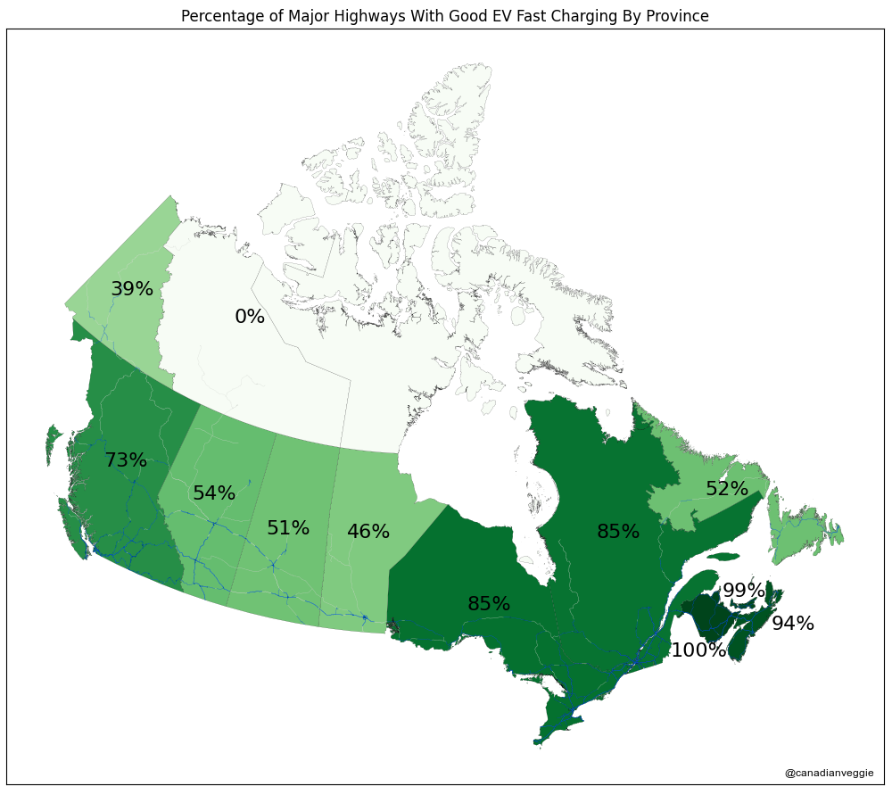
To compare the provinces, I looked at the percentage of all highway segments that are good or great (by my definitions above). It’s pretty clear where there has been investment (BC, Ontario, Quebec, and Atlantic Canada) and where investment is lacking (Alberta, Saskatchewan, and Manitoba). It’s interesting to compare this to the Electric Mobility Canada Scorecard, which ranks BC and Quebec as the leaders.
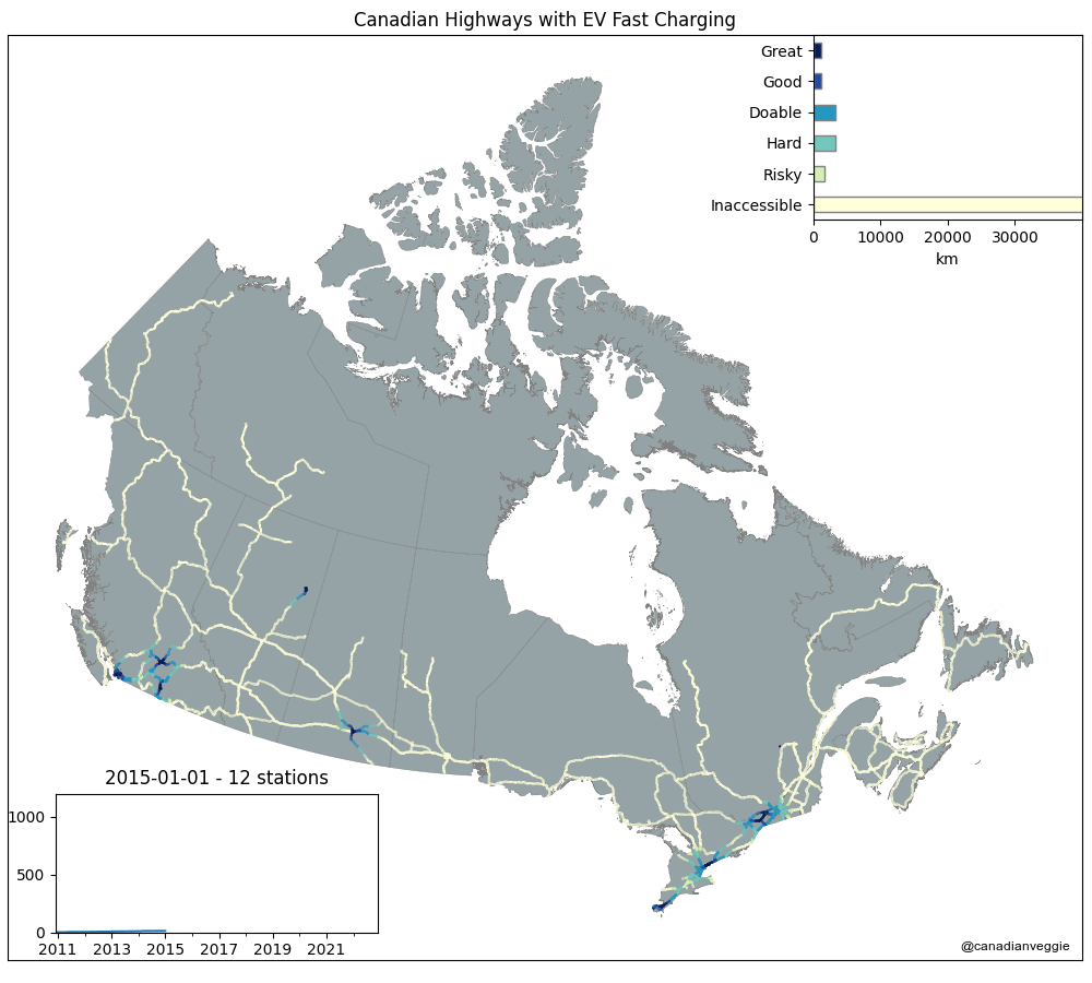
If we look at how the charging infrastructure has changed over time, we see that cross-country EV road trips were only made possible in the past 2 years. Stations continue to be added every month, and significant gaps are disappearing quickly.


There are still a few notable gaps (mainly in Western Canada) that would be filled with just 10 stations. Fast chargers in these 10 towns would ensure an extra 1,833 km of highway is within 200 km of a fast charger and make it possible to drive from Calgary to Saskatoon, Edmonton to Fort McMurray, and Winnipeg to Saskatoon.
- McLeod Lake, BC
- Grande Prairie, AB
- Whitecourt, AB
- Boyle, AB
- Hanna, AB
- Kindersley, SK
Prince Albert, SK(added on October 2)- Winnard, SK
- Yorkton, SK
- Minnedosa, MB

I also created an interactive map using Kepler.gl that you can check out here.
And if you want to dig into the code that generated all these visualizations, it’s all on my GitHub page at canadianveggie/ev-map. I’m pretty happy with how it turned out. This is my first time using GeoPandas and open-sourcing a Jupyter notebook.
And now that I have the code, I’m thinking of applying it to the United States interstate highway system next.

[…] up on my data visualization exercise assessing the fast charging capabilities in Canada, I updated my code to run the same analysis for the USA’s Interstate Highway […]
LikeLike
[…] November 2022, I created a bunch of maps visualizing the EV fast-charging infrastructure in Canada and the USA. It’s time to revisit those maps and see what has changed in the past 18 months, […]
LikeLike
Mapping Canada’s EV chargers is a game changer for EV owners and road trippers alike. As infrastructure grows, having accurate, accessible data helps drivers plan confidently and reduces range anxiety. Tools like this are vital for pushing EV adoption forward.
LikeLike